Interactive Map of Menorca with Google's technology
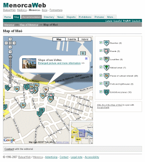
With place marks of localities, beaches, natural areas...
BalearWeb presents the beta version of the Map of Menorca. Simultaneously it presents the maps of Mallorca, Ibiza and Formentera. This is an ambitious project, based on Google Maps technology, with place marks of outstanding spots around the Balearic Islands. It features pictures of localities, beaches, lighthouses and ports, natural areas, places of cultural interest and events, with their geographic coordinates and other useful details. It also situates all the exhibition sites such as museums, art galleries and cultural centres that form part of the Diary of Exhibitions.
More over the information is available in KML format via files that can be viewed with the desktop application Google Earth.
This project will grow constantly with the inclusion of new pictures and details. Currently the group includes almost 700 references, although the map Map of Menorca still has some important missing points and the contents of the Map of Mallorca are in an initial stage.
© 1996-2024 BalearWeb / Menorca - Advertising - Contact - Legal note - Accessibility